


Saracen Casino & Resort Off-Site Roadway Improvements, Phase I
LOCATION
Pine Bluff, AR
SCOPE OF WORK
Survey, Geotechncial Investigations, Roadway Design, Drainage Design, Services During Construction
CLIENT
Brock Eubanks
Saracen Development
Authority
(918) 965.9071
MCE provided civil engineering services for design of off-site roadway improvements on four highways: Hwy. 65, Hwy. 65B, Hwy. 63, and I-530 Frontage Rd. Highway 65 is a north/south roadway. It is fourlanes and is located north of the development. It is a principal arterial. Improvements included a right turn lane and lighting. MCE will also provide a traffic signal plan for the Highway 65/I-530 Frontage Road intersection in Phase II, pending a warrant analysis.
MCE is also working on a new entrance from Hwy. 65B. Highway 65B is a four-lane, principal arterial running north/south west of the development.
Highway 63 is an east/west roadway. It is two-lanes and is located north of the development. It is classified as a minor arterial. The improvements included a multilane roundabout at the entrance.
I-530 Frontage Rd. is a north/south roadway. It runs parallel with Hwy. 65 before turning to run parallel to Hwy. 65B. It is two lanes and is located south of the development. It is classified as a local road. The improvements included extending to serve as the south entrance, inclusion of a right turn lane at the I-530 Frontage Rd./Hwy. 65 intersection, lighting, and overlay of the existing facility. In addition to design, MCE oversaw construction of the project, and coordinated for improvements to be constructed in the ARDOT’s right-of-way. The project was designed and constructed in less than 12 months (September 2020).
 |  |  |  |
|---|
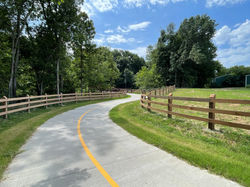
Spring Creek Trail
LOCATION
Springdale, AR
SCOPE OF WORK
Survey, Trail Design, Geotechnical Investigation, Signage, Fencing, Erosion Control, Water Main Relocation
CLIENT
Ben Peters, PE, City Engineer
City of Springdale
201 Spring Street
Springdale, AR 72764
(479) 750.8105
bpeters@springdalear.gov
The project involved extending the existing 12-foot-wide concrete Spring Creek Trail to the west. The newly designed trail spans 2,192 linear feet along the watercourse, traversing a combination of open fields and dense woodlands until it reaches an at-grade crossing at 40th Street. As it continues westward, it meanders alongside the southern bank of Spring Creek for 2,235 linear feet through the Arkansas Game and Fish Commission’s JB and Johnelle Hunt Family Ozark Highlands Nature Center, concluding at it current termination/turnaround point.
The project’s design scope encompassed topographic and geotechnical investigations, trail design, use of corten steel pedestrian bridges, bicycle and pedestrian pavement markings, signage, and coordination with franchise utilities. The construction was successfully completed at a cost of $1.9 million, with funding provided by the City, and ARDOT TAP grant, and financial support from a local foundation.
MCE is currently designing Phase III, which involves a 0.5-mile extension, guiding the trail under I-49 alongside Spring Creek, concluding at Whittle Road. Much of this extension falls within the floodway/floodplain of Spring Creek. Advanced HEC-RAS modeling was employed for this trail section to ensure a No-Rise condition of the water level of Spring Creek upon completion of construction. The design will include specific erosion control measures due to the trail’s location within the Spring Creek floodplain, in addition to standard design features typical of mutliuse trails.
 |  |  |  |
|---|---|---|---|
 |  |
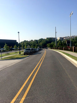
Stadium Drive Improvements & Realignment
LOCATION
Fayetteville, AR
SCOPE OF WORK
Survey, Engineering Design Services, Drainage, Utility Services, Roadway Design & Engineering, Construction Administration/Observation, Geotechnical Investigations
CLIENT
Scott Turley
University of Arkansas
521 S. Razorback Road
Fayetteville, AR 72701
(479) 575.5050
MCE provided roadway design services to the University of Arkansas for work on Stadium Drive, between Martin Luther King Jr. Blvd. and Meadow St., per the U of A Master Plan. This project included extensive coordination with property owners, phasing of utility improvements and relocations, demolition of multiple houses, and realignment of the existing street. The project site is a heavily-traveled area during school/college terms because it is located on a key street corridor used by Fayetteville High School and the U of A. The area made for critical scheduling and coordination with many differing entities.
MCE proposed mini-roundabouts were the first of their design in the state. Street improvements included: asphalt street surfaces, concrete curbs and gutters, underground storm drainage system and concrete sidewalks. MCE coordinated the street design and construction with franchise utility companies to ensure adequate space, and timely relocations. The design included 4,000 LF of two-lane roadway with parallel parking, associated storm sewer, sanitary sewer and water line design, along with the design of the mini-roundabouts. The roundabouts incorporate some important new driver aids to improve safety, including recessed reflectors around the center island perimeter and approaches to the splitter islands, collapsible illuminated bollards directing traffic flow and textured, colored courtstone paving to delineate areas of pavement for use only by trucks and buses.
This project was a joint effort between the U of A, the City of Fayetteville, and Fayetteville High School. It was constructed in five phases, over a period of three years, at a cost of $4.6 million. Construction of the final phase was completed in the latter part of 2019.
 |  |  |  |
|---|